
|
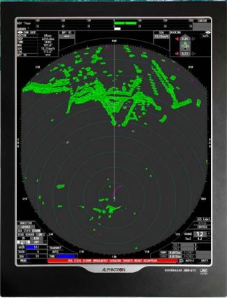
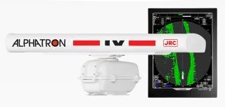
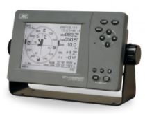
JMR611 River RadarThe next generation river radar from Alphatron Marine / JRC is the JMR-611 radar. This radar is characterized on open water by an excellent suppression of wave action (if a GPS compass is connected) and has a particularly attractive user interface. Both monitors meet the new reflection requirements that are currently imposed on radars. Due to the use of an aerodynamic scanner and accompanying engine, this radar is extremely suitable for the most extreme weather conditions The JMR-611 radar is the first river radar which in combination with a GPS compass and smart calculation technology is able to minimize the annoying waves on large water, without losing sight of the small echoes. By connecting a GPS compass you achieve the maximum functionality of this radar. Such as the Sea State function, AIS display, own vectors, docking, true trails and RTH-up function. By connecting the radar to a GPS compass, the true movements of ships can be shown, without the image being filled with relative afterglow trails. A great help in recognizing objects without AIS and determining moving targets. For a sharper display of the radar echoes, the radar is equipped with the Echo Border function. In combination with the Expansion function, the echoes will be shown with a clear outline. Sea State functionThe JMR-611 radar is the first river radar which in combination with a GPS compass and smart calculation technology is able to minimize the annoying waves on large water, without losing sight of the small echoes. Prediction linesThe unique docking & prediction lines introduced with the JMA-609 radar has been improved for the JMR-611 radar. By this improved calculation technique 2 stable lines are shown from the fore and aft ship. These lines (vectors) indicate where the ship will be in a set time. This feature is available if there is a GPS compass or 2 GPS antennas (1x fore and 1x stern) installed. 102-RadarRiv JRC JMR-611 |
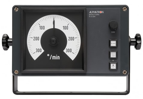 |
Basicturn Swing MeterThe Basicturn is one of the products from the Basicline. The Basicturn is an rate of turn (swing meter) system, which has been specially developed for inland shipping to show vessels the actual rate of turn value. The Basicturn has been developed specifically for the inland river market. It can be used as a standalone rate of turn indicator. However, in combination with the Alphatron Marine river auto pilot this Basicturn forms the ideal autopilot for various types of inland shipping vessels. Especially push boats and tow boats appreciate the tough design and exterior.The Basicturn has a galvanic separted signal output that can be connected for example to the turn indicator on the radar monitor. It has an output as well for the autopilot. Apart from this, the Basicturn has an alarm output showing whether the turn indicator is in alarm mode. 164-ROT AM BasicTurn |
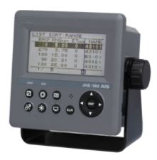 |
JHS-183 Class A AISThe JHS-183 AIS is a ship borne system capable of regularly broadcasting own ship’s unique information and continually receiving and displaying information broadcast from other vessels. The AIS can "see around corners", allowing avoidance of dangers before visual contact has been established. All ship’s information including static and voyage related data such as the ship’s name and cargo, as well as its dynamic navigational information, i.e., position, course, and speed can be transmitted and received. The JHS-183 is an important piece of navigation equipment onboard for collision avoidance and maneuvering. The information broadcast from other ships displayed on the AIS, together with the geographical information shown on the radar or ECDIS provides highly important data for strategic decisions and for prompt contact with other ships. The JHS-183 is able to display up to 200 AIS targets and the excellent on-screen menus will greatly shorten most users' learning period. 180-AIS JRC JHS-183 |
 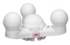 |
JRL-21 Satellite CompassThe JLR-21 GPS compass continues the success of its predecessor, reaching a new level of performance and stability with many new features and enhancements. This system is also known as a 3D Dynamic Sensor™, which besides giving heading information, is designed to provide highly accurate information of the ships movement in all axis. The JLR-21 has heave functionality built-in as standard. In rough ocean conditions (with high waves), the GPS compass can correct up and down (attitude), movement. JLR-21 supports Speed Over Ground (SOG) and Course Over Ground (COG). The position, SOG and COG are updated every 200 milliseconds (which is 5 times faster than previous model JLR-20), delivering high accuracy. |